Delaware County’s Planner’s Portfolio series can help identify options for improving your community.
The Planner’s Portfolio series is an easy-to-read information series on a range of planning-related community topics. Each issue covers a unique topic and provides strategies to achieving common community goals.
Questions about the Planner’s Portfolio series? Contact the Planning Department at 610-891-5200 or Planning_Department@co.delaware.pa.us.
* Browsers other than Internet Explorer or Microsoft Edge are recommended for optimal performance.


Delaware County Planning offers model ordinances that serve as guides for municipalities looking to update their current ordinances.
After working with municipalities, the Delaware County Planning Department often identifies a need for further guidance on complex topics. Often, municipalities request help in ensuring that their ordinances are compliant with new standards and techniques in the field. To address this need, the Planning Department has created several plans and models to assist municipal leaders in updating and maintaining their current ordinances. These guides can be found below.
Questions about a Model Ordinances? Contact the Planning Department at 610-891-5200 or Planning_Department@co.delaware.pa.us.

Preservation Planners work closely with the Heritage Commission to promote historic preservation throughout the County.
The Delaware County Heritage Commission has regular monthly meetings open to the public. They meet the first Tuesday of each month (excluding June, July, and August) in the Planning Department, 2 W. Baltimore Avenue, Suite 202, Media, PA. The Commission is charged with coordinating and promoting the cultural heritage of Delaware County. It is composed of 11 members appointed by County Council who serve on a volunteer basis. Heritage Commission members elect their Chairman and Vice Chairman, and the Planning Department provides professional planning services for the Commission.
MISSION
The Heritage Commission’s mission is to oversee the rich heritage of Delaware County and to support those organizations within the County that are promoting and preserving our cultural legacy. Commission members accomplish this mission through outreach within the historic communities of Delaware County, as well as providing a resource base for these organizations and individuals.
To get in touch with a member of the Heritage Commission, contact the Planning Department at 610-891-5200 or DelawareCountyHeritage@co.delaware.pa.us.
WHO WE ARE
WHAT WE DO
UPCOMING EVENTS
The 11th issue in the Planner’s Portfolio series focuses on nationwide trends that may affect local communities.
Research on trends occurring nationwide helps to provide insight into changing patterns and attitudes locally. It also helps to predict future pressures that may affect local communities. As such, it is important to have a broad understanding of several key national trends to understand the context of local trends. Many of these trends are influenced by the coming of age of millennials, a group that grew up during big events like the great recession and the popularization of the internet. Such events have had great influence on patterns of consumption and lifestyle, affecting housing, retail, transportation, and even changing the workplace itself. It is important that local officials continue to address the different needs of a changing population.
With significant changes in the age of population comes a need for different housing types. As population ages there is more demand for smaller housing units with less maintenance. At the same time, millennials entering the workforce are looking for high-quality units in locations that provide good access to jobs and flexibility in case they need to move for another job.
Transportation will also change as new technologies in the twenty-first century significantly alter the way that people get around. The invention of autonomous vehicles and transportation network companies (TNC’s) such as Uber and Lyft will have large impacts on transportation. Because TNC’s are so easily used through mobile devices, many communities will see an increase in drop-off/pickup traffic.
The cultural shifts that are occurring as a result of the economic recession and changing population of the country are significantly altering the workforce. Because millennials are on the verge of comprising the largest portion of the workforce, employers will also locate offices and employment centers in areas where millennials want to live and work – namely areas with a mix of uses and access to transit. As competition for talent between employers continues to grow, it is likely that the younger generations will continue to switch jobs much more frequently than any previous generation.
The retail industry has been significantly changed by the exponential growth of online shopping over the past decade. Many nation wide retailers have started to close physical stores to devote more resources to online commerce. At the same time, however, some online retailers have also started to develop physical stores. Online retail is changing the perception of in-store shopping from a ‘chore’ to a ‘leisure experience’ to be enjoyed.
For more information, check out the National Trends issue or the entire Planner’s Portfolio series.
Delaware County Planning has several reports and plans available for reference.
The Planning Department has several plans and publications available on this site. Join our email list for periodic updates on new publications and Department news.
Questions about Department Publications? Contact the Planning Department at 610-891-5200 or Planning_Department@co.delaware.pa.us.
MUNICIPAL OFFICIALS DIRECTORY
DELAWARE COUNTY 2035
- Land Use Framework Plan (2013)
- Open Space, Recreation, and Greenway Plan (2015)
- Economic Development Plan (2017)
- Implementation Metrics Report (2017)
- Transportation Plan (2017)
- Historic Preservation Plan (2018)
- Housing Plan (2020)
ENVIRONMENTAL AND GREENSPACE PLANNING
- Darby Borough Potential Brownfields Report
- Darby Creek Stream Valley Park Master Plan
- Darby Creek Trail Phase 2 Feasibility Study
- Delaware County Return on Environment Study
- Delaware Countywide Model Stormwater Management Ordinance
- Delaware River Watershed Conservation Plan
- Little Flower Open Space Master Site Development Plan
- Greenway Plan for the Darby Creek Watershed
- Media-Smedley Connector Trail Feasibility Study
- Mineral Hill Area Parks Master Plan
- Natural Heritage Inventory
- Primary Trail Network Connectivity Ranking
HISTORIC PRESERVATION PLANNING
- ADA at Historic Sites
- Delaware County Design Guidelines: A Template for Municipalities
- Delaware County Public History Feasibility Study and Implementation Plan
- Historic Preservation Directory of Trades, Services, and Products
- Maintaining Your Historic Home: A Practical Guide for Homeowners
LAND USE PLANNING
- COUNTY SUBDIVISION AND LAND DEVELOPMENT ORDINANCE (SALDO)
- Activity Corridors Model Zoning Ordinance
- Central Places Model Zoning Ordinance
- Chester Pike Corridor Master Plan
- Design Guidelines for Activity Corridors
- Design Guidelines for Central Places
- Steps Toward Walkability
PLANNER'S PORTFOLIO EDUCATION SERIES
- Aging In Place
- Automated Vehicles
- Character Areas
- Community Placemaking
- Community Trails
- Complete Streets
- Downtown Revitalization Case Studies
- Food Systems
- Form-Based Code
- Funding Sources
- Green Stormwater Infrastructure
- Healthy Communities
- Medical Marijuana
- National Trends
- Renewable Energy
- Riparian Buffers
- Tactical Placemaking
- Traffic Calming
TRANSPORTATION PLANNING
- Delaware County Official Road Map
- Improving Safety along Route 291
- Public Transit map and guide
- Upper Chichester – Route 322 Improvement Project Corridor Study
* Browsers other than Internet Explorer or Microsoft Edge are recommended for optimal performance.
The 1st issue in the Planner’s Portfolio series focuses on defining the Character Areas identified in Delaware County 2035.
The Planning Department is developing a Planner’s Portfolio series, an easy-to-read information series on a range of planning-related community topics. Each issue covers a unique topic and provides strategies to achieving common community goals.
The first issue focuses on defining the Character Areas that are identified in Delaware County 2035, the County’s comprehensive plan. It organizes the diverse place types of the County into Character Areas and Central Places. The County has four Character Area types, which are broad areas with similar development patterns and characteristics. Most communities have a spectrum including all four Character Areas and any individual location includes characteristics of multiple Character Areas.
The four types of Character Areas are: Mature Neighborhoods, Growing Suburbs, Greenways, and Open Space. There are also four types of Central Places; all are community focal points that reinforce or establish a sense of place and character. The four types of Central Places are: Urbanized Centers, Town Centers, Neighborhood Centers, and Activity Corridors.
The Planner’s Portfolio series will focus on Mature Neighborhoods, Growing Suburbs, Central Places (Urbanized Centers, Town Centers, and Neighborhood Centers), and Activity Corridors. This issue emphasizes the unique characteristics of these areas to give a better understanding of the issues and opportunities they face.
For more information, check out the Character Areas issue or the entire Planner’s Portfolio series.
The 2nd issue in the Planner’s Portfolio series focuses on defining the Character Areas identified in Delaware County 2035.
Community Placemaking is an approach to community planning and redevelopment that emphasizes local community strengths and characteristics. This includes both physical characteristics, such as parks, housing styles, and transportation, as well as less concrete elements such as special event programming. While often taken for granted, these are the features that comprise the very fabric of our communities. It is important that they are all considered together to promote a positive relationship between them.
Simply put, community placemaking is a focus on what makes a town, street, or park special. This issue of the Planner’s Portfolio series focuses on the different types of elements that contribute to placemaking and how to maintain and/or create them.
Residential land use accounts for approximately 46% of the land in Delaware County. As such, it plays a big part in creating the places and character of the County. Mature neighborhoods have a tremendous mix of housing types that create unique neighborhoods. When infill development occurs, it is important to build houses and structures that fit within the contextual aesthetic of a community to build on that community character.
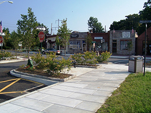
Placemaking concepts are perhaps most common in the Central Places of the County, even if they are not always obvious. Central Places are great examples of how small design and development choices can add up to bigger change: the sidewalks here are slightly wider, inviting more pedestrians; the streets are slightly narrower, slowing down traffic and increasing safety; stores fill the first floor of multi-story buildings, providing interest to the building façade; unique wayfinding orients visitors and provides a visual identity. Together, these elements help to differentiate the ‘downtown’ area from the rest of the community.
For more information, check out the Community Placemaking issue or the entire Planner’s Portfolio series.
The 3rd issue in the Planner’s Portfolio series focuses on defining the elements that comprise Complete Streets.
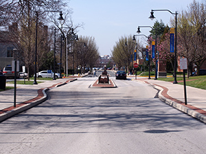 A Complete Street is a multimodal transportation policy that aims to accommodate all users on roadways, whether those users are driving, bicycling, walking, or taking public transportation. This is accomplished by prioritizing the design and planning processes for providing transportation infrastructure such as enhanced crosswalks and sidewalks, bike lanes, streetscaping and furniture, and appropriately sized roads in ways that optimize accessibility and mobility instead of building infrastructure that supports a singular mode. Complete Streets have proven to increase safety, reduce congestion, enhance and revitalize communities, and provide additional transportation options for communities nationwide.
A common misconception for Complete Streets is the idea that every element must be present in order for a roadway to classify as such. To the contrary, while similar elements are present in many of the Complete Streets examples found nationwide, it is the expected levels of activity on specific roadways that determine what the minimum standards for a Complete Street are in various neighborhoods.
For example, a Central Place with wide sidewalks, curb extensions, embellished crosswalks, and on-street parking would not be appropriate in a Growing Suburb consisting of less dense collector and arterial streets. Here, the provision of sidewalks, enhanced crosswalks, and pedestrian refuge islands are several of the most important Complete Streets components suitable for a Growing Suburb street typology which are typically wider roadways with generally lower levels of bicycle and pedestrian activity than a Central Place.
This portfolio provides great local examples of Complete Streets in various community and neighborhood types. For more information, check out the Complete Streets issue or the entire Planner’s Portfolio series.
The 5th issue in the Planner’s Portfolio series focuses on renewable energy systems and their regulatory issues.
In an age of wildly fluctuating energy costs and growing environmental consciousness, many property owners are opting to install small-scale renewable energy systems to offset the amount of energy they need to draw from the electric grid. In the past, these systems were too costly to be widespread, but advances in technology as well as government incentives and private investment have caused the system costs to decrease dramatically in recent years. Owing to the relative rarity of renewable energy installations previously, most municipalities have not included language in their ordinances to regulate the location, size, or approval procedure for these systems. While it is uncommon for municipalities to out-and-out prohibit renewable installations in their boundaries, not addressing renewable energy at all can still hinder the process. Approving zoning variances and special permits for renewables can cost both the municipality and the applicants time and money, which can serve to discourage the adoption of renewable energy systems.
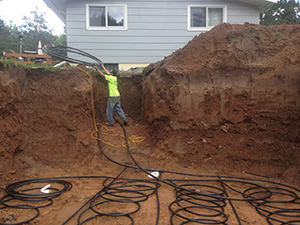
Renewable Energy systems have different issues in the County’s various Character Areas. Growing Suburbs are frequently ideal for renewable energy systems. Large open areas can accommodate geothermal wells, ground-mounted solar, or even small wind systems. These areas can enhance their natural benefits by creating a favorable regulatory environment by establishing sensible, permissive regulations for renewables and streamlined permitting processes to encourage the renewable market.
Mature Neighborhoods can pose a challenge to the installation of renewables owing to the density of the building stock. Geothermal systems must usually be dug vertically, and there could be difficulty getting large boring equipment onto a small site. Similarly, it would be difficult to erect free-standing wind structures to the necessary height to avoid obstructions and access the strongest winds. Mature tree coverage can reduce the effectiveness of rooftop solar, and smaller, older buildings might not have enough roof area or appropriate underlying structures to support an adequately sized system. Still, there are a number of opportunities to be found in Mature Neighborhoods as well. Smaller buildings, particularly those built with a party wall such as twins, row homes, and connected blocks of retail, tend to be more energy efficient to begin with, meaning that a smaller renewable system would still have a significant impact on overall energy use. Additionally, a lot of the more urban development features flat roofs, which are ideal for solar installations.
This portfolio aims to provide municipal officials with an overview of renewable energy technology and terminology, as well as the most practical way to regulate it while still providing a renewable-friendly market. For more information, check out the Renewable Energy issue or the entire Planner’s Portfolio series.
The 6th issue in the Planner’s Portfolio series focuses on Green Stormwater Infrastructure.
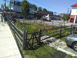
Green Stormwater Infrastructure (GSI) utilizes landscaped areas to address stormwater runoff. It is a cost-effective approach to manage the impacts of stormwater by directing it away from municipal stormwater systems and into vegetated areas that are designed to infiltrate, or absorb, the runoff.
GSI offers a range of benefits beyond stormwater management and can contribute to the beautification and regreening of an area while also increasing pedestrian safety along roadways. Many public works projects, such as new streetscapes, offer a great opportunity to incorporate GSI into their community as a part of other, ongoing improvement efforts.
For example, in the past, street specifications often required unnecessarily wide streets. More recently, studies show that narrower street widths can accommodate local traffic volumes and parking while also calming traffic. By modifying side streets to be narrower, long-term repaving and maintenance costs are lowered and the reclaimed area provides space to install green stormwater infrastructure. Infiltration gardens in curb bump-outs can manage significant amounts of stormwater runoff along a roadway.
Improving the design of streets and parking lots along Activity Corridors can turn a functional feature into an asset. Aesthetics are improved by adding swales, rain gardens, tree islands, and hardy landscaping to streets and parking lots. If curbs are depressed, pressure on the municipality’s stormwater conveyance system can be reduced by directing water off of the street and into planted areas designed to handle the stormwater.
For more information, check out the Green Stormwater Infrastructure issue or the entire Planner’s Portfolio series.