The 5th issue in the Planner’s Portfolio series focuses on renewable energy systems and their regulatory issues.
In an age of wildly fluctuating energy costs and growing environmental consciousness, many property owners are opting to install small-scale renewable energy systems to offset the amount of energy they need to draw from the electric grid. In the past, these systems were too costly to be widespread, but advances in technology as well as government incentives and private investment have caused the system costs to decrease dramatically in recent years. Owing to the relative rarity of renewable energy installations previously, most municipalities have not included language in their ordinances to regulate the location, size, or approval procedure for these systems. While it is uncommon for municipalities to out-and-out prohibit renewable installations in their boundaries, not addressing renewable energy at all can still hinder the process. Approving zoning variances and special permits for renewables can cost both the municipality and the applicants time and money, which can serve to discourage the adoption of renewable energy systems.

Renewable Energy systems have different issues in the County’s various Character Areas. Growing Suburbs are frequently ideal for renewable energy systems. Large open areas can accommodate geothermal wells, ground-mounted solar, or even small wind systems. These areas can enhance their natural benefits by creating a favorable regulatory environment by establishing sensible, permissive regulations for renewables and streamlined permitting processes to encourage the renewable market.
Mature Neighborhoods can pose a challenge to the installation of renewables owing to the density of the building stock. Geothermal systems must usually be dug vertically, and there could be difficulty getting large boring equipment onto a small site. Similarly, it would be difficult to erect free-standing wind structures to the necessary height to avoid obstructions and access the strongest winds. Mature tree coverage can reduce the effectiveness of rooftop solar, and smaller, older buildings might not have enough roof area or appropriate underlying structures to support an adequately sized system. Still, there are a number of opportunities to be found in Mature Neighborhoods as well. Smaller buildings, particularly those built with a party wall such as twins, row homes, and connected blocks of retail, tend to be more energy efficient to begin with, meaning that a smaller renewable system would still have a significant impact on overall energy use. Additionally, a lot of the more urban development features flat roofs, which are ideal for solar installations.
This portfolio aims to provide municipal officials with an overview of renewable energy technology and terminology, as well as the most practical way to regulate it while still providing a renewable-friendly market. For more information, check out the Renewable Energy issue or the entire Planner’s Portfolio series.


The 6th issue in the Planner’s Portfolio series focuses on Green Stormwater Infrastructure.
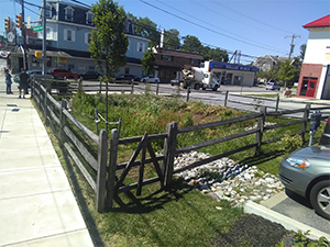
Green Stormwater Infrastructure (GSI) utilizes landscaped areas to address stormwater runoff. It is a cost-effective approach to manage the impacts of stormwater by directing it away from municipal stormwater systems and into vegetated areas that are designed to infiltrate, or absorb, the runoff.
GSI offers a range of benefits beyond stormwater management and can contribute to the beautification and regreening of an area while also increasing pedestrian safety along roadways. Many public works projects, such as new streetscapes, offer a great opportunity to incorporate GSI into their community as a part of other, ongoing improvement efforts.
For example, in the past, street specifications often required unnecessarily wide streets. More recently, studies show that narrower street widths can accommodate local traffic volumes and parking while also calming traffic. By modifying side streets to be narrower, long-term repaving and maintenance costs are lowered and the reclaimed area provides space to install green stormwater infrastructure. Infiltration gardens in curb bump-outs can manage significant amounts of stormwater runoff along a roadway.
Improving the design of streets and parking lots along Activity Corridors can turn a functional feature into an asset. Aesthetics are improved by adding swales, rain gardens, tree islands, and hardy landscaping to streets and parking lots. If curbs are depressed, pressure on the municipality’s stormwater conveyance system can be reduced by directing water off of the street and into planted areas designed to handle the stormwater.
For more information, check out the Green Stormwater Infrastructure issue or the entire Planner’s Portfolio series.

The 7th issue in the Planner’s Portfolio series focuses on Revitalizing Downtowns.
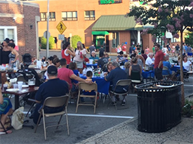
The idea of a “downtown” brings images of bustling shops, outdoor seating, and community events to mind for many people. It is often a walkable destination integrated into the surrounding neighborhoods; they can be found in both Mature Neighborhoods and Growing Suburbs (for more information on Mature Neighborhoods and Growing Suburbs, see Issue 1 of the Planner’s Portfolio Series—Character Areas). Streets typically have improved pedestrian amenities, such as wider sidewalks, benches, and enhanced crosswalks. Mixed land uses, with a range of building sizes and density, lead to unique character and identity for these areas.

Real estate trends in recent years show an increased desire for homes within or near a vibrant and walkable downtown area. The Central Places, or downtowns, of Delaware County generally developed around mass transit hubs or intersections of roadways. This historical development pattern gives these communities a distinct advantage in a market with an appetite for walkable downtowns. Communities can look to other downtowns in the region as models of success and follow similar steps toward improvement.
In all of the case studies highlighted in this document, the efforts taken by the community and nonprofit organizations have inspired growth and bustling downtowns. It is important to note that different communities are nearly always at different stages in this progression and that a thriving downtown does not occur overnight, but rather an accumulation of efforts over time.
In Lansdowne Borough, for example, the Lansdowne Economic Development Corporation (LEDC) formed in 1998 to address a decline in business and increase in vacancy. The group worked to streamline improvement efforts by unifying a vision for the community and acting as the coordinating organization for all of the stakeholders involved. In the spring of 2011, LEDC worked with Lansdowne and Yeadon Borough to start an Elm Street Program to apply similar revitalization efforts to the surrounding residential neighborhoods.
These case studies are a brief summary of how each downtown has taken steps toward positive change over the years, which may serve as a model for your community.
For more information, check out the Downtown Revitalization Case Studies issue or the entire Planner’s Portfolio series.
The 8th issue in the Planner’s Portfolio series focuses on Traffic Calming.
Traffic Calming is a transportation planning tool used to address high traffic volumes and speeding; reduce collision frequency and severity; reduce cut-through traffic; and increase access for all modes of transportation. The term traffic calming refers to three activities known as, “the three Es:” Education, Enforcement, and Engineering. Education refers to the dissemination of safety information to the public. Enforcement is police enforcement of speed limits and other traffic control devices. Engineering involves changes in roadway design that sustain safer driving.
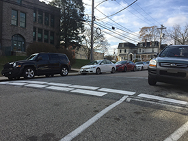
The goals of traffic calming are to encourage “self-policing” and make streets safe for a variety of users, including bicyclists and pedestrians. Traffic calming measures are not an appropriate solution for all roadways.
This issue of the Planner’s Portfolio series focuses on the most common and effective engineered traffic calming measures in Delaware County. Signs and pavement markings are a more affordable way to help reduce speeding, but they are not as effective as engineered roadway improvements.
Engineered traffic calming measures are appropriate on local residential streets, collector streets with predominantly residential land uses, and arterial roads within downtown districts or commercial areas with speeds of up to 40 miles per hour (Traffic Calming Handbook, PennDOT, 2012). Some such measures include curb extension/bulbout, on-street parking, traffic circle or roundabout, speed humps, brick paver crosswalks, and raised intersections.
This portfolio aims to provide municipal officials with an overview of engineered traffic calming measures and other speed-reduction techniques. This portfolio also outlines traffic calming best practices to mitigate emergency response delays.
For more information, check out the Traffic Calming issue or the entire Planner’s Portfolio series.
The 9th issue in the Planner’s Portfolio series focuses on design options for community trails.
Pedestrian paths and multi-use trails have become increasingly popular for satisfying transportation and recreational needs. They provide connections between communities and natural and historic resources, enhance recreational opportunities, and often conserve linear open spaces. In doing so, trails also provide a valuable recreational and fitness opportunity for all users.
Delaware County identified a Primary Trail Network as part of its Open Space, Recreation, and Greenway Plan (2015) to help create a cohesive trail system. It represents a countywide network of multi-use trails capable of connecting to both regional and municipal trail systems and destinations, such as parks and commercial centers. Municipalities should consider developing their trails in such a manner that they either construct segments of this network or design their internal trails to connect to Primary Trails.
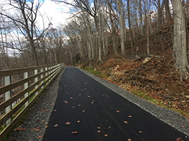
Multi-use trails are paved paths generally ten- to twelve-feet wide that can be used for non-motorized activities such as walking, running, bicycling, etc. Trailheads, which may include parking, are located at various points along the length of the trail to provide access. Multi-use trails serve as both recreational amenities and transportation corridors for the community. While they primarily serve the communities immediately surrounding the trail, they attract visitors and trail users from other communities as well.
As multi-use trails are developed to provide connections, it is inevitable that they will cross roadways. Crossings should be designed to be extremely visible and provide adequate warnings to trail users as well as vehicles and pedestrians along the roadway. On many roadways, flashing signals can be activated by trail users to warn vehicles of cross-traffic on the trail. Painted crosswalks and other traffic-calming devices, such as medians, can help to slow down vehicular traffic and provide safer crossings.
Gates are installed across the trail to limit unauthorized vehicles while still providing space for trail users. The gates can be opened by first responders in the event of an emergency or for routine maintenance access.
Trails can take a variety of sizes and styles. This issue of the Planner’s Portfolio series focuses on the different styles of trails and bicycle connections and also discusses trail amenities.
For more information, check out the Community Trails issue or the entire Planner’s Portfolio series.
The 10th issue in the Planner’s Portfolio series focuses on the importance of Riparian Buffers.
The term riparian buffer describes an area of perennial vegetation that lies adjacent to a body of water. Establishing a healthy riparian buffer provides countless benefits to a community and the watershed at large. Riparian buffers are important for stormwater management, water quality protection, flood mitigation, wildlife habitat, and they even provide economic benefits. Unfortunately, there is no “one size fits all” guideline to create a buffer due to the unique issues faced in every watershed. The role of the municipality is to encourage restoration and protection of its riparian buffer areas.
Establishing a healthy riparian buffer can be done with the regulatory help of environmental ordinances, zoning, subdivision and land development ordinances (SALDOs). Partnerships with local watershed organizations, universities, and other interested parties can help determine funds and recruit volunteers for riparian restoration.
This document aims to provide municipal officials with background knowledge on the role riparian buffers play in watershed health. Many of the examples shown are local, and may prove to be a model for further restoration throughout the county.
For more information, check out the Riparian Buffers issue or the entire Planner’s Portfolio series.
The 12th issue in the Planner’s Portfolio series focuses on a flexible approach to project planning.
Tactical placemaking is an increasingly popular approach to planning that emphasizes testing projects through a series of phases rather than constructing projects straight from the drawing board. Common examples include crosswalks, pedestrian plazas, and bicycle lanes. Projects begin as demonstrations, become pilot projects, and then, if successful, are installed permanently.
The iterative process of tactical placemaking has the benefit of incremental development. Projects begin short-term, low-risk, and inexpensive, but lead to long term installation. The phases of construction usually include demonstrations, pilot projects, and then permanent structures.
Pilot projects involve larger budgets and greater degrees of sophistication than demonstrations. This phase serves as an intermediary between a simple demonstration and a permanent installment. Pilot projects use more durable materials such as traffic paint, steel furniture, and planters. A demonstration that marked out a curbside extension with traffic cones might be improved by a pilot project with bright paint and decorative barriers.
Permanent structures are installed after thorough consideration and experimentation. With the benefits of public input from the demonstration and experimentation in the pilot project, final installations are built to last. Permanent structures use sophisticated and long-lasting materials such as concrete, tiling, and railing as it is unlikely changes will be necessary.
For more information, check out the Tactical Placemaking issue or the entire Planner’s Portfolio series.
The 13th issue in the Planner’s Portfolio series focuses on a flexible approach to project planning.
This issue in the Planner’s Portfolio series focuses the regulation and permitting of medical marijuana grower/processor and dispensary facilities.
The Pennsylvania “Medical Marijuana Act” (PA Act 16, 2016) was passed by the Pennsylvania State Legislature in April 2016 in order to legalize the growth, processing, storage, transport, and dispensing of medical marijuana to those issued a permit for its use. This portfolio provides an overview of the guidelines put in place to regulate medical marijuana growers and dispensaries.
The state was divided into six medical marijuana regions; each of these regions received two medical marijuana growing/processing permits and multiple permits for dispensaries to distribute medical marijuana and medical marijuana products. The amount of dispensary permits allocated to each section was based on the regional population, number of patients suffering from qualifying medical conditions, and access to public transportation. The portfolio describes the application process, as well as the permitting and site requirements for growing/processing facilities and dispensaries.
There are requirements to ensure that both growing/processing facilities and dispensaries ensure that medical marijuana is received by those who are eligible. Every dispensary is required to have a physician or pharmacist in the store during all operating hours, and employees must be trained for 90 days. Both grower/processors and dispensaries must have electronic tracking, recordkeeping, and surveillance systems for all aspects of the business. Only those who are diagnosed with what the state of Pennsylvania considers a “serious medical condition” or “terminal illness” may receive a medical marijuana identification card.
For more information, check out the Medical Marijuana issue or the entire Planner’s Portfolio series.
The 14th issue in the Planner’s Portfolio outlines ways to support a healthy and equitable food system.
Food is among the most basic of daily human needs, yet it often gets taken for granted. Planners have long focused on other aspects of daily life – where we live, where we work, how we get around – but a focus on issues related to food has emerged relatively recently. Food is indeed a significant part of the urban system; how our food is produced, where and how we purchase and consume it, and how we dispose of it can have significant economic, environmental, and health impacts on our communities.
A food system is an interdependent network that integrates food production, processing, distribution, consumption and disposal. It operates within and is influenced by the social, political, economic, and, environmental conditions of a community or region. Therefore, the food system has strong connections with many other planning topics including economic development, community health, social equity, agriculture, and environmental sustainability.
Due to its interconnected nature, it is difficult to separate the food system from other areas. Food system planning involves the integration of food system issues into policies, plans, and programming at all levels of government, but also involves buy-in from private businesses and the general public. More and more planners have engaged in encouraging a comprehensive food system planning process at the community, regional, and national levels. Concerns about food production, insecurity in food access, and food waste have led to the demand for a more sustainable food system. Effective planning can help to create a local food system that is sustainable, healthful, and equitable as well as efficient and profitable.
For example, food access encompasses all the issues related to connecting people to a variety of fresh, healthy, and quality food options. Access to healthy food may be hindered by a number of factors ranging from economic issues like income, or physical issues such as distance to a food market. In some areas, distribution of both healthier and less-healthy food options may be unequally concentrated in different neighborhoods, but planners can help address these disparities through the use of planning tools such as zoning and special studies.
For more information, check out the Food Systems issue or the entire Planner’s Portfolio series.

The State Association of Boroughs offers a variety of in-person and online training courses for municipal elected and appointed officials.
IN-PERSON TRAINING:
The Pennsylvania Municipal Planning Education Institute (PMPEI) was developed as a collaboration between the Pennsylvania Chapter of the American Planning Association and the Pennsylvania State Association of Boroughs to provide unique educational services to municipal elected officials and staff.
There are four core courses in the PMPEI Planning and Zoning Course Program. Each is an in-depth 10 hour course taught by two PMPEI Certified Instructors. Participants receive the Pennsylvania Municipalities Planning Code, a Course Handbook with related information and thumbnail visual aids, and other materials they use for hands-on experience with the course content. All courses are continuously updated to include the latest amendments to the PA Municipalities Planning Code, current state and national trends, and recent court decisions affecting planning and zoning. The courses are:
- The Course in Community Planning
- The Course in Zoning
- The Course in Subdivision & Land Development Review
- The Course in Zoning Administration
The Delaware County Planning Department periodically hosts one of the in-person course offerings, usually in the spring and fall. Please check back here to see any upcoming course offerings.
ONLINE TRAINING:
In addition to in-person trainings, sessions are also offered online at a cost of $25.00 each. The sessions below are being offered online:
Building a Strong Planning Commission
Thursday, March 26, 2026, 6:30 PM - 8:00 PM
A strong and well-organized planning commission is the key to a successful planning program. While MPC Article II provides the authority to have a planning commission, it offers no guidance for how to be an effective unit serving the elected governing body and the community. Using hands-on activities and interactive discussions this course explores the full range of a planning commission's work, how it can be organized to accomplish more of its goals, and what is needed to prepare members to get involved in the group's work.
The Limits to Zoning
Thursday, April 16, 2026, 6:30 PM - 8:00 PM
Zoning is a powerful tool of local government used in over 2000 Pennsylvania municipalities, but its power is not unlimited. Community expectations for zoning are high, but ordinance drafters and administrators must know what the limitations are and the effect they have on a municipality's zoning program. This course will explore these limitations such as those in the MPC itself, the Police Power, non-conforming use property rights, and state and federal laws impacting local zoning. This is not a zoning case law update, but it is an interactive discussion of common zoning issues with an opportunity to look at them in the context of the course.
The Zoning Officer & Zoning Hearing Board
Thursday, May 7, 2026, 6:30 PM - 8:00 PM
The MPC states that every municipality that enacts a zoning ordinance shall create a zoning hearing board and it must have an official who handles the day-to-day work of administering the ordinance. This online class will review the job each is responsible for, along with the basic terms used in zoning, special exceptions, variances, nonconformities, notice of violation of the ordinance, plus the basics of the zoning hearing process.
Managing the Subdivision Review Process
Wednesday, May 20, 2026, 6:30 PM - 8:00 PM
Subdivision and Land Development ordinances are the most common land use regulation in the commonwealth. For many local planning commissions reviewing development applications takes up most of their meeting time. This course looks at the important work of a commission in managing the review process. The review process is tightly structured by the Municipalities Planning Code and many procedures can easily be misunderstood and create problems for municipal planners and officials. This course examines the complex review process and points out problem areas and how to avoid them. It describes how planning commissions, with project applicants, are engaged in a collaborative process to build the future community. Included in the course are hands-on discussions of problem situations.
For questions on registration, contact Dani Baker-Papinchak at dbaker@boroughs.org.
Register for this class at www.myaccount.boroughs.org; click on register for training.
For information about these courses and other PMPEI offerings, please visit the PMPEI website.
Questions about a PMPEI workshop? Contact the Planning Department at 610-891-5200 or Planning_Department@co.delaware.pa.us.