The Delaware County Transportation Plan establishes a unified vision for the county’s transportation network.
The Transportation Plan outlines a long-range strategy for the movement of people and goods in Delaware County. By examining existing conditions and emerging trends, the plan highlights opportunities to improve, expand, and integrate the county’s transportation network. The plan emphasizes the importance of making the county’s transportation more multimodal to provide safe, efficient, and reliable transportation for all users. It is a component of Delaware County 2035, the County’s comprehensive plan.
Questions about the Transportation Plan? Contact the Planning Department at 610-891-5200 or Planning_Department@co.delaware.pa.us.
View the Transportation Plan


John was appointed to the Delaware County Planning Commission in January 2019.
John has a long history of public service. He has been a resident of Concord Township for the past 21 years where he has served on the Township Planning commission, and is now in his third term on the Township Council, presently serving as Vice President. He also held appointments to the Board of View and COSA Advisory Council in Delaware County.
After serving in the Army during the Vietnam era, he graduated from Drexel University in Civil Engineering. He worked at Pennoni Associates for 32 years, retiring as Vice President. During his time there, he served as Municipal Engineer for 17 municipalities in Delaware, Chester, and Montgomery Counties and he is a licensed Professional Engineer in two states.
John has received numerous awards in Engineering from Drexel University and Professional Societies culminating with Engineer of the Year in Delaware County in 1997.
In addition to his township duties he helps with the management of his son’s fitness business, and volunteers with AARP and Riddle Memorial Hospital.
John's hobbies are supporting the Philadelphia sports teams, and international travel. He is married with 3 children and 7 grandchildren.

Delaware River Watershed Conservation Plan
for the Delaware River Corridor and Naamans, Marcus Hook, and Stoney Creek Watersheds
Date Published: September 2014
View PDF File [20.3mb]
View Executive Summary [.5mb]
Abstract:
The primary purpose of the Delaware River Watershed Conservation Plan is to address concerns and threats to the river’s resources. The plan identifies river [watershed] resources and makes recommendations to guide watershed conservation, restoration, and enhancement efforts.
Geographic Area:
Aston Township, Bethel Township, Chester City, Chester Township, Eddystone Borough, Lower Chichester Township, Marcus Hook Borough, Ridley Township, Tinicum Township, Trainer Borough, Upper Chichester Township
For more information or to order this report, contact the Department at 610-891-5200 or Planning_Department@co.delaware.pa.us.
Delaware County provides support to landowners for the preservation of private farmland, open space, and natural resource areas.
General Assistance
Delaware County Planning Department staff can assist landowners, municipalities, and others in finding ways to preserve and manage open space. The County’s Open Space, Recreation, and Greenway Plan is a great resource, particularly Volume I, Chapter 6: Implementation Tools. Planning staff can help you find the right tools, resources, and partners to address your particular need, whether it be an open space covenant or advice concerning other land protection strategies.
Delaware County Open Space Covenant Plan (Act 515)
Delaware County’s Open Space Covenant Plan (based on Act 515 of 1966, as amended) provides an incentive for owners of farmland or open space to remain land stewards. The Plan enables a property owner with 10 or more acres of qualifying land to receive a reduction in property tax in return for agreeing to retain his property in its current condition for at least ten years. For more information or to receive a copy of the Plan information packet, contact the Planning Department at 610-891-5200.
A similar program, based on Act 319 of 1974, often called the "Clean and Green Program," also provides a reduced property tax assessment on open space land capable of producing agricultural products, according to soil productivity. The County’s Act 319 program is administered by its Board of Assessments (610-891-4879).
Streams and their watersheds serve as a basis for County plans that address natural, cultural, recreational, and economic assets.
Commercial, industrial, natural, and recreational resources are all elements considered in a river or watershed plan. County staff actively participate in planning activities that fall under Pennsylvania’s two river-related programs. Both programs recognize the importance of preserving and enhancing the unique resources that lie within the multi-faceted areas that make up the area of land and water interface along rivers.
Coastal Zone Management
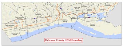
The Delaware County Coastal Zone extends along the Delaware River waterfront for 12 miles from Tinicum Township to Marcus Hook Borough. Generally following the Route 291/13 corridor, this area has continued to be the location of many of the County’s industries and port facilities. However, the 13 municipalities that lie within the area also contain unique aesthetic, environmental, cultural, recreational, and historic resources. The area has been identified as having considerable redevelopment potential, as evidenced by Talen Energy Stadium, Harrah’s Philadelphia Casino and Racetrack, and offices at the Wharf at Rivertown in Chester. It will also contain a segment of the East Coast Greenway bikeway.
Planning staff sit on the regional Delaware Estuary Coastal Zone Advisory Committee. It coordinates with the Pennsylvania Department of Environmental Protection (DEP) Water Planning Office, the Delaware Valley Regional Planning Commission, and other waterfront counties in the region on matters relating to the Pennsylvania’s Coastal Zone.
DEP’s Coastal Resources Management Program administers a grant program funded by the federal National Oceanic and Atmospheric Administration for projects in the Coastal Zone. Planning Department staff are familiar with Coastal Zone programs and policies and can assist with preparation of a Coastal Zone grant application.
Coastal Zone Projects and Activities
The Planning Department, through the Delaware County Coastal Zone Task Force, works closely with the municipalities and stakeholders to reinvigorate the Coastal Zone and draw attention to its resources.
The Planning Department regularly receives grant funding from DEP for the preparation of studies and the initiation of projects affecting Delaware County’s Coastal Zone resources. Planning projects have included inventories and studies relating to land use planning for the area, beautification of the Route 291/13 Industrial Heritage Parkway area, implementation of the East Coast Greenway bikeway, and design and installation of interpretive signage throughout the Delaware River corridor.
Rivers Conservation Plans
A Rivers Conservation Plan (RCP) serves as a vision that can be used by study area municipalities to guide conservation and development efforts into the future. The primary purpose of an RCP is to address concerns and threats to the river resources. This is accomplished through preparation of a plan that identifies river watershed resources and makes recommendations to guide watershed conservation, restoration, and enhancement efforts. The recommendations presented in the plan provide municipalities and conservation organizations with actions that can be taken to address primary concerns and to preserve the many resources of the study area documented in the plan.
RCPs approved by the Pennsylvania Department of Conservation and Natural Resources (DCNR) are placed on the state Rivers Registry. This enables projects identified in the plan to be eligible for DCNR funding for implementation.
RCPs for Darby, Chester, Ridley, Crum, and Brandywine Creek plans can be found on DCNR's website.
The Delaware River Watershed Conservation Plan for the Delaware River Corridor and the Naamans, Marcus Hook, and Stoney Creek Watersheds, prepared by the Delaware County Planning Department is available.
Planning for natural resource protection and management is an important role of the Delaware County Planning Department.
Delaware County contains a number of sensitive natural resources that include steep slopes, streams and their floodplains, wetlands, forests, and trees. It also has a number of critical habitat areas that are home to important, rare, and endangered species of plants and animals. The County recognizes the need to protect these natural resources for the long-term health, safety, and quality of life of County residents
Natural Resource Protection Assistance
The Planning Department maintains inventories and maps containing information relating to the location, extent, and environmental value of many of the County’s important natural resources. Staff are available to discuss resource extent and quality and make recommendations for their preservation and management.
Natural Heritage Inventory
The Delaware County Natural Heritage Inventory (NHI) was developed for the County by the Western Pennsylvania Conservancy. Its purpose is to inform residents and local decision makers about the unique plants, animals, and habitats that are found throughout Delaware County. The NHI is a valuable tool that can be used when preparing land use and open space plans and for making local land use decisions. DCPD staff are available to provide more information regarding the NHI and its use.
The County’s Natural Heritage Inventory
County planning staff prepare County-level open space and greenway plans that can provide guidance for municipal open space and trail plans.
Create an Open Space, Recreation, and Trail Plan
An open space, recreation, or trails plan provides a basis for local decision-making regarding future land use. The planning process typically involves working with municipal officials and staff, recreation groups, and residents to ensure that the plan reflects the community’s vision. An open space plan evaluates existing conditions and community needs and makes recommendations regarding open space acquisition for natural resource protection and public recreation. It also typically suggests park needs and improvements, and often identifies a trail network to serve the community. Additionally, the existence of a plan also helps to support applications for grant funding for recommended activities.
The Planning Department’s professional planners are available to provide technical assistance to municipalities interested in creating or updating an existing open space, recreation or trails plans.
View County Open Space, Recreation, and Trail Plans
County Open Space, Recreation, and Greenway Plan
Executive Summary
Volume I: Open Space and Recreation Plan
Volume II: Countywide Greenway Plan
Volume III: County Parks and Recreation Plan
Greenway Plan for Darby Creek Watershed
Darby Creek Stream Valley Park Master Plan
Mineral Hill Area Parks Master Plan
Little Flower Open Space Master Site Development Plan
Media-Smedley Connector Trail Feasibility Study
Delaware County Planning can work with you to create a revitalization, feasibility study, or official map.
Specialized studies are an important step towards implementing a municipal comprehensive plan or community goal. They may be in the form of a feasibility study for a specific project or a vision study to guide future efforts. The Department can assist municipalities in identifying and performing the appropriate next steps in completing a project.
Questions about Specialized Studies? Contact the Planning Department at 610-891-5200 or Planning_Department@co.delaware.pa.us.
Revitalization or Redevelopment Plan
A Revitalization or Redevelopment Plan can help a community identify not only a vision for a neighborhood or area, but also the steps to achieving that vision. Common examples of these plans include a downtown revitalization plan or a corridor vision study. Blight Certification Studies are a common tool for municipalities in identifying and preparing areas for targeted redevelopment. For more information on creating a revitalization plan, check out this information sheet. Downtown revitalization is also explored in more detail through our Planner’s Portfolio on Downtown Revitalization Case Studies and Community Placemaking.
Feasibility Study
A Feasibility study is an in-depth look at the details of a specific project. This allows communities to more accurately anticipate project costs and any issues that may arise as it goes forward. They are commonly completed for trails, parks, reuse of historic structures and related topics.
Official Map
An Official Map is a map and ordinance that identifies both existing and proposed public lands and facilities within the community. The map is a declaration by the municipality that it may eventually need the mapped areas for uses and facilities that will advance and safeguard the health, safety, and welfare of the residents. The following facilities are common examples of what may be placed on the Official Map:
- Streets, sidewalks, and multi-use trails
- Parks and open space
- Transit rights-of-way and easements
- Floodplains and stormwater management facilities
- Any other proposed public facility, including municipal buildings
Adoption of the map does not in itself establish a street or imply that the municipality has taken the land; that requires a municipal purchase, or mutual agreement. Often developers prefer to work in municipalities that have an adopted official map because there is less guesswork about infrastructure location. For more information on the official map, check out this information sheet.
Funding Assistance
Regional and state funding sources may be available to support creating a specialized study. For currently available funding assistance programs, see the Funding page.
Delaware County Planning can help you update your zoning ordinance to guide development in your community.
Zoning ordinances are the legally enforceable measures that support implementation of a municipal comprehensive plan. Put simply, zoning ordinances define what land uses are allowed in specific locations, while a Subdivision and Land Development Ordinance (SALDO) defines how these uses may be built or developed. The Department can assist municipalities in Delaware County with updating their zoning ordinance, creating a zoning ordinance on a contractual basis, and finding potential funding.
Questions about Zoning Ordinances? Contact the Planning Department at 610-891-5200 or Planning_Department@co.delaware.pa.us.
Create or Update a Zoning Ordinance
When creating or updating a zoning ordinance, the Department’s professional planners work closely with stakeholders to identify community development objectives. Along with the vision detailed in the municipal comprehensive plan, these objectives become part of the new zoning ordinance and set an overall direction for the municipality. The zoning update process considers the revision and/or addition of zoning districts, as well as provisions tailored to guide growth and development in the municipality. For more information on the zoning ordinance update process, check out this information sheet.
New or revised ordinance provisions also often include:
Parking regulations
Sign regulations
Special exceptions and conditional uses
Nonconforming uses, structures, and lots
Performance standards, administration, and enforcement
After the draft document has been prepared, staff assists the municipality through the public review process and then final adoption by the local governing body.
Funding Assistance
Regional and state funding sources may be available to support your municipal zoning ordinance update. For currently available funding assistance programs, see the Funding page.
View Existing Zoning Ordinance
County Subdivision and Land Development Ordinance
Delaware County Planning can help you update your municipal comprehensive plan to help shape the future of your community.
Comprehensive Planning provides the basis for moving municipalities forward by determining the development goals and aspirations of the community. Delaware County 2035, the County’s Comprehensive Plan, was informed by municipal comprehensive planning efforts and guides County policy.
The Department is committed to helping further the integration of a sound comprehensive planning process into the daily conduct of municipal decision-making and management. The Department can assist municipalities in Delaware County with updating their comprehensive plan, creating a comprehensive plan on a contractual basis, and finding potential funding.
Questions about Comprehensive Planning? Contact the Planning Department at 610-891-5200 or Planning_Department@co.delaware.pa.us.
Create a Comprehensive Plan
When preparing a comprehensive plan, the Department’s professional planners work closely with stakeholders to identify a common vision for the future and develop strategies to achieve that vision.
A stakeholder task force is created which typically includes municipal leaders, local officials and staff, members of the business community, and local residents. The Department and task force review the history and development of the community, survey existing conditions, and project future trends. From this background and analysis, we develop recommendations to retain and enhance communities’ positive features and identify where and how improvements could be made. The entire process, from formation of a task force or steering committee to the publication of the final plan document typically takes 18-24 months. For more information on the comprehensive planning process, check out this information sheet.
Funding Assistance
Regional and state funding sources may be available to support your municipal comprehensive plan update. For currently available funding assistance programs, see the Funding page.